The information contained in this article is not intended as legal advice and may no longer be accurate due to changes in the law. Consult NHMA's legal services or your municipal attorney.
Whether you’re walking, riding a bike, in a car, truck, 18-wheeler, or futuristic hovercraft, we all want to get to our destination safely and efficiently. Not only are the ways we might travel unique, but our abilities can also vary due to age, health, and other challenges. Unfortunately, roads often do not accommodate all the different ways we might travel. Paths that were once traversed by sure-footed cows became narrow rural roads to accommodate speedy cars and trucks.
New Hampshire’s goal is to reduce the number of highway fatalities and serious injuries by half by 2035, working toward zero by 2050. However, the State has seen increases in recent years in the number of fatalities and serious injuries. According to the National Highway Traffic Safety Administration and Census Bureau, between 2011 and 2021, more than 40% of fatal bicycle and pedestrian crashes happened in New Hampshire towns with populations under 10,000. To achieve the goal of safer roads, we all need to work together, from state agencies to local governments.
When asked, New Hampshirites from rural to urban communities will tell you they want neighborhoods and village centers in which their families can walk and ride a bike. So, how can we make roads safer for all users? This article provides the tools that many communities in New Hampshire and beyond have utilized to ensure roads accommodate all users. Please join us in the discovery of complete streets in New Hampshire.
Complete Streets Projects in New Hampshire
Have you experienced this: you’ve traveled to another state and discovered that the place you’re visiting has a fantastic road network, one that has been designed for people walking, riding on two wheels, or driving behind one. You find yourself at ease as you discover the village center, and you notice all roadway users have designated space. Designing roads for all users is to deliberately construct a complete street network. It just so happens that we have some places right here in New Hampshire that have considered all roadway users in their design. Over the last decade, a number of complete streets projects have been implemented across the Granite State, from the southwest’s hamlets to the Merrimack Valley’s mills, all the way over to the historic seacoast.
Concord’s award-winning, revitalized Main Street set a high bar for the rest of the state to follow, but an array of upcoming projects will ensure the ethos of complete streets is continued into the future. One such project is Dover’s downtown pedestrian and vehicular access improvements project. This project will bring the 2015 Downtown Pedestrian and Vehicular Access and Streetscape Study into design and ultimately create construction plans. It would implement the improvements identified by the study, ensuring streets are safe and accessible for all users regardless of age, physical ability, or mode of transportation.
Making the Commitment to Complete Streets – Policies and Resolutions
Perhaps you are wondering how communities made these projects happen. It all starts with a local commitment from community staff and public officials to ensure that the local street network is safe and accessible. One way to start is to look at available resources. Smart Growth America, a proponent of complete streets, has documented over 1,700 policies adopted throughout the country. Smart Growth America offers research, guides, examples, a rating tool and more.
A good complete streets policy will articulate the community’s vision for safe streets, the geographic extent in which the policy applies, exceptions to the policy, ability to serve underinvested communities, design guidance and of course steps and responsible parties to oversee implementation. Municipal policies should also speak to the desired level of coordination between a municipality and the New Hampshire Department of Transportation (NHDOT). Policies can take many different forms and shapes ranging from resolutions to departmental policies to ordinances and more. From the date of adoption forward, a complete streets policy serves as a guide and resource to achieve safer streets for all road users – regardless of how travelers get around.
Presently New Hampshire has no State-enacted policy; however, one is currently under development. At the community level, a total of 15 local complete streets policies have been adopted starting in 2010 with Concord. Southwest New Hampshire has the highest density of policies adopted by local officials. Since 2015, Southwest Region Planning Commission (SWRPC) has worked with a total of 10 communities to craft local policies and design guidelines. To view projects and policies across the state, check out this interactive complete streets resource map at https://arcg.is/uPj0P. (Please note this map is still under construction.)
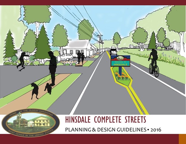
One example of note is the Town of Hinsdale's complete streets policy, developed with help from SWRPC. The policy is accompanied by a design guidelines document to assist the Town with decision-making and project planning.

By adopting complete streets policies, New Hampshire towns and cities can ensure a standardized and systematic approach to retrofitting existing roads and building new ones that meet safety and accessibility goals. Implementing complete streets design modifications will not happen overnight. Taking a complete streets approach across a road network will take years to implement, and a strong, thoughtful policy can provide a community with the compass for staying on track.
Starting with Demonstration Projects
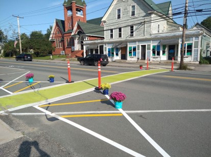
Another method that will provide insight into creating a more user-friendly roadway is to coordinate a temporary demonstration project. North Country Council (NCC) regional planning commission hosted a week-long traffic calming pop-up in the rural town of Bethlehem in early September 2023. Despite its small population of 2,484, the town has significant traffic along its built-up Main Street that doubles as U.S. Route 302. This route is one of the most important East-West corridors in the North Country for freight, commerce, tourism, and general travel by local residents. The goal of the project was to lower traffic speeds, improve the visibility of pedestrians and cyclists for motorists, and reduce the crossing times for pedestrians.
Thanks to a successful collaborative process with local officials, community representatives, and NHDOT, all necessary approvals were given for pop-up planning elements including materials and design. Leading up to the event, NCC staff reached out to local businesses, groups, and residents with flyers, a survey, and emails with details about the demonstration event. Staff also attended the local farmers market to connect with citizens about the project.
NCC staff used a combination of temporary pavement tape, traffic cones, and flower planters to mark intersections and sidewalk crossings. To analyze the effectiveness of the temporary set up, staff set up three traffic counters before and during the event to study how the installations impacted traffic along the route. Staff found that there was a 6, 7, and 1 mph reduction in speeds at the three separate traffic counter locations during the event.
 Temporary traffic calming features in Bethlehem town center, NCC
After the event, NCC drafted a report detailing the process, speed data, and observations during the event as well as notes on possible options and price estimates to permanently improve traffic safety. After being presented with the results of the pop-up, The Bethlehem Selectboard organized a traffic calming task force to implement the recommendations in the report. To view the report go to : https://www.nccouncil.org/wp-content/uploads/2024/03/Bethlehem-Pop-Up-Report-Final-2023-1.pdf.
Traffic safety is a universal issue no matter the size or character of your community. You can probably point to a state route, high-speed stretch of road, unsafe intersection, or other feature in your community that creates traffic safety concerns. The pop-up in Bethlehem showed that even simple treatments at a few important locations can have a major impact on a community.
NHDOT’s Complete Streets Advisory Committee
The New Hampshire Complete Streets Advisory Committee (CSAC) advises the NHDOT Commissioner on policies, programs and recommendations to support bicycling, walking, and transit as safe, convenient, economically and environmentally beneficial forms of transportation and recreation. The CSAC is also envisioned to serve as a forum for exchange of information, ideas, and resources related to bicycling, walking and transit among NHDOT, other state agencies, local and regional planners, and community organizations. To learn more or to get involved, please visit:
SNHPC Complete Streets Toolkit
In 2023, Southern NH Planning Commission (SNHPC) staff undertook an update of its original 2016-17 Complete Streets Toolkit, which was a multi-year effort that included pilot projects in Deerfield, Francestown, and Windham. The toolkit’s goal was to develop a resource guide for how to implement Complete Streets principles, policies, and projects for communities within the SNHPC region and beyond. The toolkit includes:
- An overview of Complete Streets – what they are, their history, and community examples in NH and beyond
- A review of the SNHPC regional effort to incorporate complete streets in project planning with community stakeholders
- A Planning and Policy section that includes the benefits of complete streets, policies in our region, and rural, suburban, and urban examples
- Design and Engineering examples for a variety of needs such as bicycle and pedestrian facilities, accessible accommodations, and transit
It provides a history and overview before delving into the multifaceted benefits of policies, highlighting the policies and resolutions within New Hampshire, and finally getting into the nitty-gritty of street design in various contexts including urban, suburban, and rural. The updated toolkit can be found on the SNHPC website at
https://www.snhpc.org/transportation/multimodal-programs/pages/complete-streets.
Other Complete Streets Resources
Interested in learning more about complete streets? Here are a few more resources to peruse, including the interactive map SNHPC staff developed just for this article.
(https://smartgrowthamerica.org/10-elements-of-complete-streets/
(https://www.bikewalkmontana.org/news-1/pop-up-traffic-calming-guide-ava…)
(https://ruraldesignguide.com/)
Interested in learning more about what is happening in your region to address “getting there,” visit the NH Association of Regional Planning Commissions to connect with the regional planning commission in your area.
